A Sahara Project?

No, clouds aren't really the problem.
I didn't say clouds would be a problem, I said cloud formations were unpredictable (because they are) and water vapor is the number one greenhouse gas:

Water vapor is also a potent greenhouse gas. Because the water vapor content of the atmosphere will increase in response to warmer temperatures, there is a water vapor feedback is expected to amplify the climate warming effect due to increased carbon dioxide alone. It is less clear how cloudiness would respond to a warming climate; depending on the nature of the response, clouds could either further amplify or partly mitigate warming from long-lived greenhouse gases.
 
Werbung:
Let me refresh from the link I posted on the previous page. And I quote:
The principal reason is that water vapor has a short cycle in the atmosphere (a few days) before it is incorporated into weather events and falls to Earth, so it cannot build up in the atmosphere in the same way as carbon dioxide does

Here's a project egypt has been kicking around. http://www.unu.edu/unupress/unupbooks/80858e/80858e0a.htm

An excerpt:

Two solar-hydro and pumped-storage projects are being considered, in Israel and Egypt. The Israeli plan involves constructing a long pipeline/tunnel between the Mediterranean and the Dead Sea (400 m below sea level) to exploit the differences in elevation between these two bodies of water. The Egyptian plan involves transfer of water from the Mediterranean to the Qattara depression (a basin in the Western desert of about 26,000 km², the floor of which is 120 m below sea level). Both plans involve an initial development stage in which the basins are filled with water from the Mediterranean Sea up to a certain design level that will be maintained later by the transfer of water to replace the amount evaporated. A very similar type of solar-hydro scheme has also been studied for the Assal lake in Djibouti, which has the shortest conduit, with a length of about 15 km from the Red Sea to the Assal depression.
 
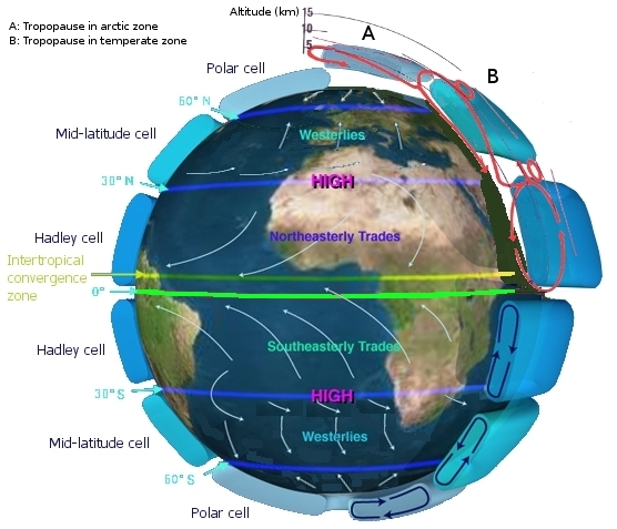
Has anyone found a 'JETSTREAM' map of this region...
Earth_Global_Circulation.jpg
 
That's a nice map. Perfect in fact. It looks like the trade winds would take the evaporated moisture from the proposed "Qattara Sea" and spread them both back to the east and then south again, as well as to the west and south...throughout the most arid regions of the Sahara. The western Sahara might need its own project but for now the Qattara project looks promising.
 
That's a nice map. Perfect in fact. It looks like the trade winds would take the evaporated moisture from the proposed "Qattara Sea" and spread them both back to the east and then south again, as well as to the west and south...throughout the most arid regions of the Sahara. The western Sahara might need its own project but for now the Qattara project looks promising.
Is there any information on seasonal changes in the jetstream, any records that track this for at least a 50 year span?

BTW, excellent map that's what my mind said we needed but my inability to find it was very very frustrating!

Almost beginning to feel like we need to start splitting into teams and doing a 3-D diorama/feasibility study...get this thing planned and written up...good grief the sluggish mind cells are starting to regenerate :eek:
 
Seems like Algeria and Egypt would be on board. Egypt already considered it and Algeria has been battling the encroachment of the Sahara towards the coastal region for some time.

There are few animals and people who would be affected or displaced. Even the nomads there avoid the Qattara depression because of lethal brackish marshes there. Seems like a no-brainer given that it's a mess now and if it had to be pumped out again, no big deal?
 
It sounds like you have it pretty much figured out. Now, let's put a map together and show exactly where the beach would be. I want to start buying property now, before the value goes up.
 
Seems like Algeria and Egypt would be on board. Egypt already considered it and Algeria has been battling the encroachment of the Sahara towards the coastal region for some time.

There are few animals and people who would be affected or displaced. Even the nomads there avoid the Qattara depression because of lethal brackish marshes there. Seems like a no-brainer given that it's a mess now and if it had to be pumped out again, no big deal?

Had this thought wake me up out of a good snooze last night; if this would work for this area why wouldn't pumping/building a pipeline from the Pacific into the salt flats create a inland pool like it once was Millions of years ago? How hard would that be compared to building a huge oil supply line in one of the coldest regions known to mankind!
 
Well yeah that was the point, to not blast a hole into the Mediterranian that couldn't be replugged. I guess I should've been more specific.

Good point PC. Real estate too! Egypt would be goofy to not do it.
 
In the Sahara we see evidence of old water bodies that have dried up. Having a water body present to induce evaporation within a warm season fuels the wet-weather precipitation and literally dictates the type of eco-zone the area is.

We can see the interim results of this type of drying in the Owen's Valley of the Eastern Sierra range in CA. Los Angeles stealthily bought up nearly all the land in the Owen's Valley and claimed the water rights to the old Owen's Lake, which used to be vast and supplied the Eastern Sierra with critical evaporation and moisture necessary to its frail ecology. In the last several decades as the lake dried up further and further, more and more forests on the eastern side of the Sierras began to become stressed and susceptible to insect attack and drought conditions. Snowpack in the Sierras has also been affected. This snowpack feeds the entire state and is heavily relied on for agriculture in the Central Valley to supply food for the entire US and parts of the world.

So in selling off this critical body of water to Los Angeles' unending and ever-growing thirst, the state scratches its head and wonders why droughts and water supply for agriculture are headaches for the region?

Silly humans..
:rolleyes:

In college I took many courses on ecosystems and their interaction. What really helps to pass these courses is to pull way back and look at the earth like a kid looks at an antfarm. When you do this it is simplicity itself to see and predict what will happen at a given place if you do something else to somewhere else.

If we restore inland water bodies within the Sahara, it is easy to predict-in-reverse, using the Owen's Valley model that revegitating and revitalizing will occur by nothing more than increasing localized evaporation. It's a theory I have. I wish I was as rich as Bill Gates so I could influence it and make it happen.

Did they tell you about the now dry Tulare Lake as well? That one must be having quite an impact on the Central Valley, probably more impact than the ban on pumping water out of the delta has had.

You're right: Back up and look at the larger picture, and you can see what effects a change might produce. California is a great example of everyone looking at their small source of water, while ignoring the fact that the overall supply of water is diminishing while we use up water that probably fell as snow back during the ice age.
 
Well yes so I'm extrapolating good news in the reverse model as with my fantasy Qattara Project.
 
Today there is/was a special on How The Earth Was Made featuring the latest understanding of the Sahara, it's old waterways and settlements of only 5,500 years ago.

The change from savannah to desert was nearly instantaneous, blamed on the earth's wobble and yet I'm pretty sure that in 200 years a climate could not change over such a vast area so drastically without some other explanation.

In any event there exists vast aquifers of ancient water underneath the sandstone there and they're wanting to tap it to restore the desert to agriculture. However they're concerned it will depeat the aquifer in no time at all without new rains.

Solution: Create evaporating seawater ponds to increase rainfall and greening there.

Watch the show tonight.
 
Werbung:
Today there is/was a special on How The Earth Was Made featuring the latest understanding of the Sahara, it's old waterways and settlements of only 5,500 years ago.

The change from savannah to desert was nearly instantaneous, blamed on the earth's wobble and yet I'm pretty sure that in 200 years a climate could not change over such a vast area so drastically without some other explanation.

In any event there exists vast aquifers of ancient water underneath the sandstone there and they're wanting to tap it to restore the desert to agriculture. However they're concerned it will depeat the aquifer in no time at all without new rains.

Solution: Create evaporating seawater ponds to increase rainfall and greening there.

Watch the show tonight.
What channel/show/time is that coming on??? QUICK, I don't want to miss it! ;)
 
Back
Top