Anti-drilling bastion surrenders

Libsmasher

Well-Known Member
Joined
Jan 9, 2008
Messages
3,151
Santa Barbara, a resort community on the california coast, and probably the previous center of opposition to coastal drilling, has gone on record in favor of it now. The county supervisors voted to approve it.

http://www.montereyherald.com/news/ci_10314557

Bit by bit, economic reality seeps into the brains of the ecofascist dupes. :D
 
Werbung:
After the hurricane, those numbers will change back to anti-offshore when all the oil starts to wash ashore..

Mark my words.

Meanwhile some things to consider about offshore drilling off the West Coast:

The oceans in the vast majority of areas where offshore would be implemented along the West Coast are very, very rough in the Winter time (swells up to 50' and high winds common during the many increasingly-violent storms there) and riddled with seismic faults that are long overdue for massive rupture and rig-wrecking potential. In several areas along the West Coast, earthquakes ranging from conservative values of 8 to even 9 magnitude are long overdue in their cyclic patterns. No oil rig could survive an 8, much less 9 earthquake. And surviving the yearly Winter mini-hurricane storms would be a constant gamble there.

It's not so simple as you think, your offshore-drilling dreamland. And Californians specifically will lock elbows from San Diego to Crescent City to bar construction of offshore rigs. Sabatoge would also be a constant threat, especially in the Golden State.
 
After the hurricane, those numbers will change back to anti-offshore when all the oil starts to wash ashore..

Mark my words.

Won't happen - mark my words. The main problem with Katrina was poorly sited and unprotected onshore facilities - this is just a stupid mistake - not an inherent impediment.

Meanwhile some things to consider about offshore drilling off the West Coast:

The oceans in the vast majority of areas where offshore would be implemented along the West Coast are very, very rough in the Winter time (swells up to 50' and high winds common during the many increasingly-violent storms there) and riddled with seismic faults that are long overdue for massive rupture and rig-wrecking potential. In several areas along the West Coast, earthquakes ranging from conservative values of 8 to even 9 magnitude are long overdue in their cyclic patterns. No oil rig could survive an 8, much less 9 earthquake. And surviving the yearly Winter mini-hurricane storms would be a constant gamble there.

It's not so simple as you think, your offshore-drilling dreamland. And Californians specifically will lock elbows from San Diego to Crescent City to bar construction of offshore rigs. Sabatoge would also be a constant threat, especially in the Golden State.

I live 5 miles from the ocean in california, and you don't know what you're talking about. There is always a succession of winter storms, no worse than eg what there is in the north sea in europe during winter, and no platform there has ever failed. I disagree that they've been increasingly violent, and I live there. There is NOTHING to compare to Katrina - hurricanes don't come here. :rolleyes: There is the artic ocean current which cools the water along the west coast, not anything like the gulf of mexico which is warm. There has never been a >= 8.0 verified earthquake in california history - the worst one was the Fort Tejon earthquake (7.9) 151 years ago. There is no perfect energy production method, but that is the only kind ecofascists want. It is actually YOU who are in dreamland.
 
You are basing the argument for geothermal and anti-offshore drilling on the fact that maybe an earthquake will hit a platform?

Pretty weak argument in my opinion.
 
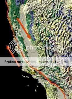
sanandreasfault.jpg

Source: http://www.answers.com/topic/san-andreas-fault

Southern, central, and northern segments

The San Andreas Fault can be divided into three segments.

The southern segment (known as the Mojave segment) begins near the Salton Sea at the northern terminus of the East Pacific Rise and runs northward before it begins a slow bend to the west when it meets the San Bernardino Mountains. Here, it runs along the southern base of the San Bernardino Mountains, crosses through the Cajon Pass and continues to run northwest along the northern base of the San Gabriel Mountains. These mountains are a result of movement along the San Andreas Fault and are commonly called the Transverse Range. This segment of the fault is the most commonly analyzed of any fault in the world by geologists. This is due to a cutout of the fault in Palmdale (the second largest city directly sitting on the fault) where the Antelope Valley Freeway passes through it, and the deep layers of "shifted" crust can clearly be seen.

After crossing through Frazier Park, the fault begins to bend northwards. This area is referred to as the "Big Bend" and is thought to be where the fault locks up in Southern California as the plates try to move past each other. This section of the fault has a recurrence interval of roughly 140-160 years. Northwest of Frazier Park, the fault runs through the Carrizo Plain, a long, treeless plain within which much of the fault is plainly visible. The Elkhorn Scarp defines the fault trace along much of its length within the plain.

The central segment of the San Andreas fault runs in a northwestern direction from Parkfield to Hollister. While the southern section of the fault and the parts through Parkfield experience earthquakes, the rest of the central section of the fault exhibits a phenomenon called aseismic creep. This term describes the fault being able to move without causing earthquakes.

The northern segment of the fault runs from Hollister, through the Santa Cruz Mountains, epicenter of the 1989 Loma Prieta earthquake, then on up the San Francisco Peninsula, where it was first identified by Professor Lawson in 1895, then offshore at Pacifica at Mussel Rock. This is the approximate location of the epicenter of the 1906 earthquake. The fault returns onshore at Bolinas Lagoon just north of Stinson Beach in Marin County. It returns underwater through the linear trough of Tomales Bay which separates the Point Reyes Peninsula from the mainland, returning onshore at Fort Ross. From there it continues overland, forming in part a linear valley through which the Gualala River flows. It goes back offshore at Point Arena. After that, it runs underwater along the coast until it nears Cape Mendocino, where it begins to bend to the west, terminating at a triple junction with the Mendocino Fracture Zone and the Cascadia subduction zone. To the north lies the Gorda Plate which is being subducted under the margin of the North American plate.

That "locked up" area is exactly just inshore from the Los Angeles and Santa Barbara areas. Due to the underlying structures of the geology in the area, the fault wants to move regularly, but this area binds it up. Because it does that, the areas accumulates a much larger potential energy for great magnitudes of rupture for when that area finally slips.

And that, friends, is the area most rich in oil deposits for California...where they "want" to drill offshore (note: pockets can be padded to seem to reflect the majority of interest in an areas. But the reality is that the majority of citizenry in Los Angeles and indeed the whole State of CA is strongly Anti-offshore drilling. Challenge me and I'll post evidence of that in spades.) The billion dollar tourist industry would plummet to a pittance if LA's famous beaches were smeared with black filth from an oilspill. LA is an ugly eyesore as it is. Her beaches are her best feature. You're asking that town to commit fiscal suicide.

So again, your simplistic hopeful model of offshore drilling on the West Coast is truly a fantasy. When you start talking about faults off Alaska's West Coast, the numbers get even more nasty..

Oh well...:cool:
 
Werbung:
That "locked up" area is exactly just inshore from the Los Angeles and Santa Barbara areas. Due to the underlying structures of the geology in the area, the fault wants to move regularly, but this area binds it up. Because it does that, the areas accumulates a much larger potential energy for great magnitudes of rupture for when that area finally slips.


Gosh, thanks for explaining what everyone already knows. :rolleyes:

And that, friends, is the area most rich in oil deposits for California...where they "want" to drill offshore (note: pockets can be padded to seem to reflect the majority of interest in an areas. But the reality is that the majority of citizenry in Los Angeles and indeed the whole State of CA is strongly Anti-offshore drilling. Challenge me and I'll post evidence of that in spades.) The billion dollar tourist industry would plummet to a pittance if LA's famous beaches were smeared with black filth from an oilspill. LA is an ugly eyesore as it is. Her beaches are her best feature. You're asking that town to commit fiscal suicide.

Yawwwwn. Where to start. :rolleyes: the only valid thing you said is that LA is an eyesore - that's because it's flooded with illegal alien invaders, and is de facto part of mexico, thanks to liberals in places like the the northeast who don't know what's happening in the southwest. Your comment on the potential oil fields is glaring stupidity. The off shore oil fields would be FARRRRRRRR west of the san andreas fault - they're in the pacific plate. The people in this state have been inundated with ecofascist propaganda for 30 years. Take a valid, non-rigged poll >>NOW<< run by a reputable NEUTRAL source and see what folks have to say. The drilling restrictions off both florida and california were established largely due to the scare propaganda of wealthy coastal property owners and real estate interests. People also DRIVE A LOT in California - one way commutes of 40-50 miles are very typical. People are taking another look at the ecofascist scare tactics after spending $100 to fill their gas tanks.

So again, your simplistic hopeful model of offshore drilling on the West Coast is truly a fantasy. When you start talking about faults off Alaska's West Coast, the numbers get even more nasty..

"Simplistic model"?? :D All you did is dump some boilerplate about the san andrea fault, and then ridiculously mislocate where "offshore" would be.

Puh-leeeeeeeeese - stopping making a fool of yourself. :rolleyes:
 
Back
Top